Four Necessary Tools for Land Navigation
Backcountry navigation is becoming a lost art
The ability to read a map and use a compass to navigate through the wilderness is a skill that very few in modern times possess.
Wilderness areas are seeing more and more use as time goes on, and people's interest in the outdoors increases. With this increased use, we often see an improved infrastructure that has trails that are better maintained and clear and concise signage that includes trail names, numbers, and distances to certain locations.
This Improved infrastructure, along with the GPS software now available for smartphones has made getting lost quite difficult.
Difficult, but not impossible.
There are a handful of tools that you need before embarking on an adventure in wilderness settings. These tools, as well as how to use them, will keep you on track and see that you make it back safely from your next adventure.
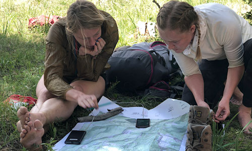
Topographic Map
If there is one thing you should always have in the backcountry it’s a topographic map. Topographic maps have a few distinct features that regular (planimetric) maps do not.
- Vegetation: Through the use of colors topographic maps show where meadows are as well as large stands of timber.
- Elevation: Through the use of contour lines topographic maps show elevation which gives the user a three-dimensional perspective of the ground they are traveling over. These lines also create shapes and patterns which identify specific terrain features.
- Location: Many topographic maps have a grid system overlaid on top of the map. This grid system allows the user to quickly identify their location and the location of other objects/people.
There are various types of topographic maps available. For higher use recreational areas we suggest checking out the options from National Geographic.
If your adventure is in a more austere area we suggest building a custom map through mytopo.com.
Compass
Although there are natural ways to determine the basic cardinal directions, a compass is required to navigate effectively in the backcountry.
Now the kind of compass on a keychain, or those found in a box of Cracker Jacks, will simply not suffice. For general backcountry use, we suggest one with declination adjustment from either Suunto or Brunton.
Mapping Software
One of the easiest and most useful tools for backcountry navigation is now tied to a piece of technology that we all already own: a smartphone.
Smartphones have built in GPS capabilities that are able to function even without a cellular signal. The user can download not only topographic maps, but satellite imagery and a host of other types.
These applications sync to the user’s online account where waypoints, routes, and tracks can all be stored.
Although smartphones are probably the best navigation tool they have one major problem: they run on batteries. GPS devices and smartphones are the fastest and easiest tool for backcountry navigation but they are also the most problematic. Always carry a paper map and compass as backup.
Our favorite navigation software is GAIAGPS.com.
GPS Watch
A watch is typically part of everyone’s backcountry gear list. Some companies such as Garmin and Suunto make watches that also have GPS capabilities.
Although many of these watches offer advanced navigation features similar to what some of the mapping software out there have, their ease of use doesn’t hold a candle to what a smartphone is capable of.
A watch with GPS capabilities has two distinct features that make it worth having:
- It allows you to pull a location grid.
- It allows you to mark locations then navigate back to them.
So although not necessary, having a watch that will give you a grid and save a location is a great backup to your smartphone technology. Additionally, many watches with GPS technology also have fitness features that you’ll use daily at home.